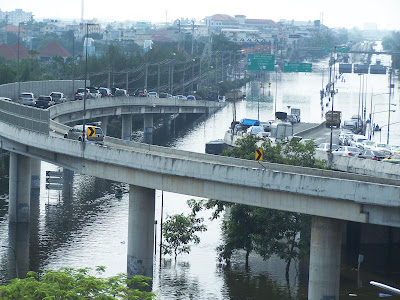
I lived in Bangkok for many years and I remember seeing Sukhumvit Road (the main drag through the newer part of the city) three feet under water with people getting to work by sampan. This report comes from a member of my personal intelligence organization, the "League of SuperFriends" - S.L.
Don Muang Airport unaffected, no noticable change in airport operations.
Route to Don Muang Airport (Vibhavadi Rangsit Rd, an elevated highway with tolls) mostly unaffected. From the northern edge of the Central Business District until the airport, in most areas (over 50%), cars were parked on the highway.
Don Muang area (North of Central Business District): there is some flooding of roads at ground level, generally to the immediate West of Don Muang airport, directly under Vibhavadi Rangsit Rd. Patches 25-100m long, down to 40cm deep, still passable by sedans.
Lak Si area (North/Northeast of Central Business District): northern road to Lak Si flooded, impassable to vehicles. (Junction of Lam Lukka Rd and Phahon Yothin Rd, approx 2km North of Don Muang airport).
Sathon area (Southwest of Central Business District, Chao Phraya riverside): water approx 50 cm below breaking banks, no indications of recent flooding, businesses continued unaffected, no indications of imminent evac by locals. However, locals expressed concern that the area may flood in 3-4 days. Defensive sandbagging (approx 25%) / concrete walls (approx 5%) were inconsistently employed.
Chao Phraya River: approx 50cm from bursting banks IVO the Mandarin Oriental Hotel and Millennium Hilton Hotel.
Chao Phraya River: minimal flooding from approx Phra Pok Klao Bridge north until Rama 8 Bridge. Poorer locals affected.
Chao Phraya River: surrounding area of the Grand Palace is flooded, palace protected by sandbags.
STORMBRINGER SENDS
Today's Bird HERE
.
Tuesday, October 25, 2011
Subscribe to:
Post Comments (Atom)


Did Yon jump in the pool AGAIN?
ReplyDelete